|
|
 
|
Leh : is the Capital of the Ladakh, and the largest town of the region. It is located to the north of the Indus River at an elevation of 3600m above the sea level. The town is dominated by the nine-storey Namgyal Palace and Namgyal Tsemo (victory peak), built by Tashi Namgyal on his victorious in reunification of the Upper and Lower Ladakh.In the later period, Leh became an important center for trade in Central Asia. Leh remained merely a headquarter of Ladakh district until 1974, |
|||||||
|
when Ladakh was opened for foreign tourists.
Since then period Leh became the centre for tourism related activities in the region. Leh is also a good
base for longer day trips out into the Indus Valley. Among the string of picturesque villages and Gompas
within reach by bus are Shey, site of a derelict 17th century palace, and the Spectacular Tikse Gompa.
Location ; North of the Indus river. Altitude: 3550m. Significance : Capital of the Ladakh | ||||||||
 |
Srinagar : is the largest city of Kashmir which is also the summer capital of Jammu and Kashmir and due
to its qualities its also a center of attraction for tourists. Srinagar is spread over an area of
103.93 sq kms. and its height above sea level is 1730 meters. This is a beautiful tourist place with
mixture of various castes, cultures and languages. The main specialty about this city are its
waterfalls and gardens made by Mughal emperors which represent the beauty of 4th and 5th century.
Various historians have different views about the establishment of Srinagar but to days truth is
that Srinagar is surrounded on both the sides of Jhelum river. Mountains covered with snow, beautiful
trees of Chinar, beautiful valleys ,world famous lakes like Nagina and Dull represents the view of
this city. Due to its nice climate Srinagar attracts tourist throughout the year. Places to Visit:
Dal Lake, Mughal Gardens, Wular Lake, Hazratbal Shrine, Shankaracharya Temple, Khanqah-e-Molla, Kheer
Bhawani, Tulip Garden, Jama Masjid. |
|
 |
Gulmarg In spring Gulmarg lives upto its name which means Meadow of flowers, its a large upland meadow
52kms southwest of Srinagar. Come winter,Gulmarg is Indias major ski resort. Location: 56-km South
West Of Srinagar, Kashmir Region, J&K .Altitude: 2,730m .Main Attractions: Alpather Lake, Golf Courses
and Skiing .How to spend time/Attractions: Golf, Trekking, Cable Car ride, Angling, Horse Riding, Skiing,
Ice Skating, Photography, Sledge Ride. |
|
|
It can be reached by roads, which runs through the picturesque Sind valley flanked on one side by the
densely populated slopes and many varieties of alpine flower Location: 81-km From Srinagar, Kashmir
Region, J&K. Altitude: 2,740m. How to spend time/Attractions: Trekking, Alpine Skiing, Angling,
Long walks, White water rafting, Sledging, Horse riding, Photography, Sightseeing, etc. | ||

|
Kumaon : proper constituted of an old Rajput principality, which became extinct at the beginning
of the 19th century after its annexation in the Gurkha war of 1815. Presently, the Kumaon (or Kumaun)
region is spread over an area of more than 35,000 sq. kms. and is headquartered at Nainital. It is one
of the two main regions and administrative divisions of Uttarakhand (earlier known as Uttaranchal), a
hilly state of northern India, the other being Garhwal. The region is spread over the districts of
Almora, Bageshwar, Champawat, Nainital, Pithoragarh, and Udham Singh Nagar with the town of Nainital
serving as the administrative center. It has the serene and peaceful Tibet towards its northern side,
on the east is the beautiful Nepal, Uttar Pradesh lies towards the south and on the west, lays the
Garhwal region. |
|
Ranikhet, at 6000 feet from sea-level, has all the ingredients of a romantic, charming, picturesque little
hill-station with its lush and dense green forests, stately mountain peaks and the exotic flora and fauna.
To experience a symphony of sight, not merely sound, the place to be is Ranikhet. The place where Ranikhet
stands is said to have impressed the queen of Raja Sudhardev, Rani Padmini, so much that she decided to
settle here itself. Since that time the place came to be known as Ranikhet which, literally, means
"Queen's Field". The soothing breeze, the music and the soulful singing of birds, the very view of the
Himalayas make your experience as good as Heaven. With the advent of the rains comes the blooming flowers
and ripened fruits on branches of stooping tress. |
|
Manali Just 40 kms away from Kullu to the north,
Manali is situated near the end of the valley on the National Highway leading to Leh. The landscape
here is breath taking. One sees well-defined snow capped peaks, the Beas river with its clear water
meanders through the town. On the other side are deodar and pine trees, tiny fields and fruit orchards.
It is an excellent place for a holiday, a favorite resort for trekkers to Lahaul, Spiti, Bara Bhangal
(Kangra), and Zanskar ranges. From temples to antiquity, to picturesque sight-seeing spots and adventure
activities, Manali is a popular resort for all seasons and for all travellers. Manali is well connected
by road with Delhi, Ambala, Chandigarh, Dehradun, Haridwar, Shimla, Dharamsala and Chamba/Dalhousie.
Regular buses ply between these stations. It is connected with Leh during July to October.
New Delhi Hotels |
 Pindari Glacier :Over the last 100 years, the
Pindari Glacier has been attracting mountaineers and trekkers from far and wide. Lying in the Bageshwar
district, it is among the most readily accessible of all the Himalayan glaciers. Pindari has amazing
rugged beauty and breathtaking sights. A trekker’s paradise, Pindari is the place where you get to see
nature at the height of its pristine glory. Terminating at an altitude of 3627 meters, the glacier
stretches between the Nanda Devi and Nandakot peaks in the Pindar valley. The Glacier measures 5 km in
length with a snout that is about 6 m high and 2.5 m wide. Above the snout, the glacier is spread over
an area about 3 km in length and 300 - 400 m in breadth. The altitude ranges between 3600 m and 5000 m.
and the total surface area of the glacier is 339.39 sq kms.
Pindari Glacier :Over the last 100 years, the
Pindari Glacier has been attracting mountaineers and trekkers from far and wide. Lying in the Bageshwar
district, it is among the most readily accessible of all the Himalayan glaciers. Pindari has amazing
rugged beauty and breathtaking sights. A trekker’s paradise, Pindari is the place where you get to see
nature at the height of its pristine glory. Terminating at an altitude of 3627 meters, the glacier
stretches between the Nanda Devi and Nandakot peaks in the Pindar valley. The Glacier measures 5 km in
length with a snout that is about 6 m high and 2.5 m wide. Above the snout, the glacier is spread over
an area about 3 km in length and 300 - 400 m in breadth. The altitude ranges between 3600 m and 5000 m.
and the total surface area of the glacier is 339.39 sq kms.
|
Dharamshala : This is a hill
station lying on the spur of the Dhauladhar range about 17 kms north- east of Kangra town. This hill
station is wooded with oak and conifer trees and snow capped mountains enfold three sides of the town
while the valley stretches in front. Khajjiar is a hill station in Chamba district, Himachal Pradesh, India, located at an approximate of 24 km from Dalhousie.The hill station is surrounded by green meadows and dense forests. It is about 6500 ft. (1981m) above sea level in the foothills of the Dhauladhar ranges of the Western Himalayas and snowy peaks can be seen in the distance.Khajjiar is often called the Mini Switzerland of Himachal Pradesh and was officially baptized thus by the Swiss Ambassador on July 7, 1992. It has a rare combination of three ecosystems: lake, pasture and forest, all in one place. The 12th-century Khajinag temple, known also as the Golden Devi temple, is a small shrine dedicated to the local Devi. Great Himalayan National Park The National Park with an area of 754 sq. km. is located in Kullu District and has the representative area of temperate and alpine forests of Himachal. It has some the virgin coniferous forests of the State. Vast areas of alpine pastures and glaciers cap this park. This area has many important wildlife species of Western Himalayas, like Musk deer, Brown bear, Goral, Thar, Leopard, Snow leopard, Bharal, Serow, Monal, Kalij, Koklas, Cheer, Tragopan, Snow cock etc. ^TOP |
 The snowline is perhaps more easily accessible at Dharamshala than
at any other hill resort . In 1905, tragedy struck Dharamshala when an earthquake levelled it completely.
After its reconstruction, Dharamshala flourished as a quiet health resort. It is divided into two distinct
parts. Lower Dharamshala has civil offices and business establishments with courts. Kotwali bazar and
Upper Dharamshala comprise of places with names which bear witness to its history like McLeod Ganj and
Forsythe Ganj. Since 1960, when it became a temporary headquarter of His Holiness The Dalai Lama,
Dharamshala has risen to international fame as "The Little Lhasa in India". Mcleodganj is 9 km from
Dharamshala. Altitude: Between 1250m to 1550m (Dharamshala) Temperature: Max. 38 C in June; Min. 0 C in
January.
The snowline is perhaps more easily accessible at Dharamshala than
at any other hill resort . In 1905, tragedy struck Dharamshala when an earthquake levelled it completely.
After its reconstruction, Dharamshala flourished as a quiet health resort. It is divided into two distinct
parts. Lower Dharamshala has civil offices and business establishments with courts. Kotwali bazar and
Upper Dharamshala comprise of places with names which bear witness to its history like McLeod Ganj and
Forsythe Ganj. Since 1960, when it became a temporary headquarter of His Holiness The Dalai Lama,
Dharamshala has risen to international fame as "The Little Lhasa in India". Mcleodganj is 9 km from
Dharamshala. Altitude: Between 1250m to 1550m (Dharamshala) Temperature: Max. 38 C in June; Min. 0 C in
January.|
 |
Sikkim -
Situated in the secluded environs of Eastern Himalaya and sharing her borders with Tibet (N),
Bhutan (E), Nepal (W) and West Bengal (S) precisely spreading below the Mt. Khang-Chen-Zongha (8534 mtrs.)
the third highest mountain in the world. |
|
|
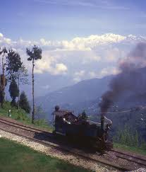
Darjeeling hill areas is unique from environmental Eco-perception. The relief varies from 100 Mts. above
sea level to the mighty Kanchanjungha. There are different climatic zones with distinctive attributes and
there are endange red animals like red panda etc along with memory orchids and medicinal plants are
available in this hilly region. The Darjeeling hill area is formed of comparatively recent rock structure
that has a direct bearing on land slides. The causes of the landslides vary from one locality to another.
Heavy monsoon precipitation is however a very common cause of these disasters. More over soils of
Darjeeling hill areas are extremely varied, depending on elevation , degree of slope, negetative cover
and obviously geolithology .
Darjeeling Tea occupies a place of pride for the whole of India. The aroma and taste of Darjeeling
orthodox tea is unparalleled in the world. There are a total of 78 tea estates in the hills which have
been accorded the status for its produce, as Darjeeling Tea by the Tea Board of India.
How To Reach Darjeeling - The nearest airport to Darjeeling is
Bagdogra about 94-96 kms away from Darjeeling.
There are direct flight connections with Delhi,Kolkata and Guwahati. Tourists heading for Darjeeling can
get direct taxis/cabs to Darjeeling from Bagdogra.The closest Railway Station is New Jalpaiguri (NJP) about
88 kms away from Darjeeling. It has direct railway connections with all over India and avail of taxi,Bus
directly to Darjeeling by road. | ||
|
Shillong -
Shillong is the capital of Meghalaya. Its picturesque setting and salubrious climate were considered
suitable for sanatoriums and holiday homes for British civilians, suffering from the sweltering heat
of the plains. It is described as 'Mini London'. There are many legends surrounding the name Shillong.
|
 Arunachal Pradesh -
Located on the easternmost Himalayas Arunachal is one of the most sparsely populated
states of India. It borders Tibet, China, Bhutan and Myanmar. Arunachal is home to more than 60
aboriginal tribal groups and sub- groups. There are five major rivers - Kameng, Subansiri, Siang, Lohit
and Tirap, which go on to form one of the biggest river systems in the world, the mighty Brahmaputra. The
snow peaked moun tain ranges of Arunachal is home to some of the tallest peaks of the world. The most
famous being Gorichen, Kangto and Takpa Shri .Bomdila The onward journey is most adventurous and perhaps
the most difficult as Bomdila, the headquarters of the West Kampeng District is at a height of 2,530 mtrs,
offering wonderfully panoramic view of Himalayan landscapes and snow clad ranges. There are apple orchards
and Buddhist monasteries, for travellers are now entering an area that has had strong Tibetan and Buddhist
influence, over the centuries.
Tawang, a Buddhist Pilgrimage site, where the Dalai Lama, the spiritual leader of the Tibetans, goes to preach
and pray. The most striking building in this Buddhist village is the tall central monastery, the Tawang Gompa.
The 400 year old monastery dominates the valley with grand view of the Himalayas. Prayer flags flutter in
the breeze and inside, the monks - there are some 500 lamas - light lamps, rush about their chores and
drone in joint prayer. An 8 meter high guilded statue of Buddha is here.
Arunachal Pradesh -
Located on the easternmost Himalayas Arunachal is one of the most sparsely populated
states of India. It borders Tibet, China, Bhutan and Myanmar. Arunachal is home to more than 60
aboriginal tribal groups and sub- groups. There are five major rivers - Kameng, Subansiri, Siang, Lohit
and Tirap, which go on to form one of the biggest river systems in the world, the mighty Brahmaputra. The
snow peaked moun tain ranges of Arunachal is home to some of the tallest peaks of the world. The most
famous being Gorichen, Kangto and Takpa Shri .Bomdila The onward journey is most adventurous and perhaps
the most difficult as Bomdila, the headquarters of the West Kampeng District is at a height of 2,530 mtrs,
offering wonderfully panoramic view of Himalayan landscapes and snow clad ranges. There are apple orchards
and Buddhist monasteries, for travellers are now entering an area that has had strong Tibetan and Buddhist
influence, over the centuries.
Tawang, a Buddhist Pilgrimage site, where the Dalai Lama, the spiritual leader of the Tibetans, goes to preach
and pray. The most striking building in this Buddhist village is the tall central monastery, the Tawang Gompa.
The 400 year old monastery dominates the valley with grand view of the Himalayas. Prayer flags flutter in
the breeze and inside, the monks - there are some 500 lamas - light lamps, rush about their chores and
drone in joint prayer. An 8 meter high guilded statue of Buddha is here. One says that it originated from the name of a handsome youth called Shyllong. Forested Shillong Peak,
at 1,965 metres above sea level, acts as a vast catchment area. A steep winding road goes right to the
top of the peak. On a clear day, you can see the Himalayan peaks and plains of Sylhet from the summit.
One says that it originated from the name of a handsome youth called Shyllong. Forested Shillong Peak,
at 1,965 metres above sea level, acts as a vast catchment area. A steep winding road goes right to the
top of the peak. On a clear day, you can see the Himalayan peaks and plains of Sylhet from the summit.

